Page 88 - LIT-18626-14-67
P. 88

SportsBoat_F7G10.book  Page 79  Wednesday, June 14, 2023  9:23 AM


                        Instrument operation

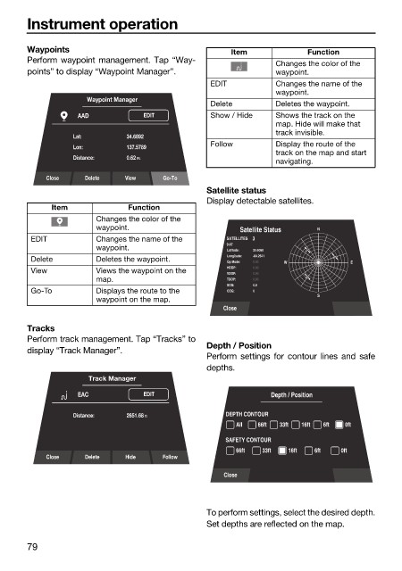
                        Waypoints                                  Item            Function
                        Perform waypoint management. Tap “Way-              Changes the color of the
                        points” to display “Waypoint Manager”.              waypoint.
                                                              EDIT          Changes the name of the
                                                                            waypoint.
                                     Waypoint Manager
                                                              Delete        Deletes the waypoint.
                                   AAD           EDIT         Show / Hide   Shows the track on the
                                                                            map. Hide will make that
                                                                            track invisible.
                                  Lat:       34.6892
                                                              Follow        Display the route of the
                                  Lon:       137.5789
                                                                            track on the map and start
                                  Distance:    0.62 Ft.
                                                                            navigating.
                            Close   Delete   View    Go-To
                                                              Satellite status
                                                              Display detectable satellites.
                             Item            Function
                                       Changes the color of the
                                       waypoint.                     Satellite Status  N
                         EDIT          Changes the name of the    SATELLITES     3
                                                                  9:47
                                       waypoint.                  Latitude:  35.6060
                         Delete        Deletes the waypoint.      Longitude:  -84.2541  W   E
                                                                       0.00
                                                                  Op Mode:
                         View          Views the waypoint on the   HDOP:  0.00
                                                                  VDOP:  0.00
                                       map.                       TDOP:  0.00
                                                                  SOG:  0.0
                         Go-To         Displays the route to the   COG:  0
                                                                                     S
                                       waypoint on the map.
                                                                 Close
                        Tracks
                        Perform track management. Tap “Tracks” to
                                                              Depth / Position
                        display “Track Manager”.
                                                              Perform settings  for contour lines and  safe
                                                              depths.
                                     Track Manager
                                   EAC           EDIT                      Depth / Position
                                  Distance:    2651.68 ft         DEPTH CONTOUR
                                                                    All  66ft  33ft  16ft  6ft  0ft
                                                                  SAFETY CONTOUR
                                                                    66ft  33ft  16ft  6ft  0ft
                            Close   Delete   Hide    Follow
                                                                 Close


                                                              To perform settings, select the desired depth.
                                                              Set depths are reflected on the map.

                        79
   83   84   85   86   87   88   89   90   91   92   93