Page 69 - LIT-18626-14-66
P. 69

SportsBoat_F5K13.book  Page 61  Tuesday, June 13, 2023  5:43 PM


                                                                 Instrument operation

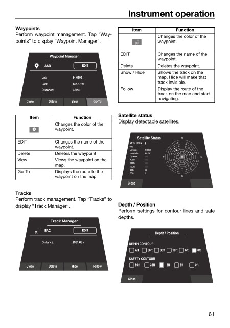
                        Waypoints                                  Item            Function
                        Perform waypoint management. Tap “Way-              Changes the color of the
                        points” to display “Waypoint Manager”.              waypoint.


                                     Waypoint Manager         EDIT          Changes the name of the
                                                                            waypoint.
                                   AAD           EDIT         Delete        Deletes the waypoint.
                                                              Show / Hide   Shows the track on the
                                  Lat:       34.6892                        map. Hide will make that
                                  Lon:       137.5789                       track invisible.
                                  Distance:    0.62 Ft.       Follow        Display the route of the
                                                                            track on the map and start
                                                                            navigating.
                            Close   Delete   View    Go-To

                                                              Satellite status
                             Item            Function
                                                              Display detectable satellites.
                                       Changes the color of the
                                       waypoint.
                                                                     Satellite Status  N
                         EDIT          Changes the name of the    SATELLITES     3
                                       waypoint.                  9:47
                                                                  Latitude:  35.6060
                         Delete        Deletes the waypoint.      Longitude:  -84.2541
                                                                  Op Mode:  0.00  W         E
                         View          Views the waypoint on the   HDOP:  0.00
                                                                  VDOP:  0.00
                                       map.
                                                                  TDOP:  0.00
                                                                  SOG:  0.0
                         Go-To         Displays the route to the
                                                                  COG:  0
                                       waypoint on the map.                          S
                                                                 Close
                        Tracks
                        Perform track management. Tap “Tracks” to
                        display “Track Manager”.              Depth / Position
                                                              Perform settings  for contour lines and  safe
                                                              depths.
                                     Track Manager
                                   EAC           EDIT
                                                                           Depth / Position
                                  Distance:    2651.68 ft
                                                                  DEPTH CONTOUR
                                                                    All  66ft  33ft  16ft  6ft  0ft
                                                                  SAFETY CONTOUR
                            Close   Delete   Hide    Follow         66ft  33ft  16ft  6ft  0ft

                                                                 Close


                                                                                               61
   64   65   66   67   68   69   70   71   72   73   74